
ECDIS SYSTEMS
© by Raytheon
ECDIS – Electronic Chart Display and Information System (as defined by IHO Special Publications S-52 and S-57) is an approved marine navigational chart and information system, which is accepted as complying with the convention paper charts required by Regulation V/20 of the 1974 IMO SOLAS Convention. The performance requirements for ECDIS are defined in by the International Electrotechnical Commission (IEC) in Specification 61174
ECS – Electronic Chart System

RASTER charts:
• ARCS (official) (11CDs or 1DVD) + weekly updates (Name of the charts – the same as paper charts)
VECTOR Charts:
• IHO S-57 (official) ->Transfer standard for Digital Hydrographic Data -> Local Hydrographic Vector Charts
• IHO S-63 (PRIMA Charts) (official) –> International Hydrographic Vector Charts (S-57 + encryption)
• ENC Database (official) - contain all the chart information necessary for safe navigation, and may contain supplementary information in addition to that contained in the paper chart (e.g., Sailing Directions). These supplementary information may be considered necessary for safe navigation and can be displayed together as a seamless chart. ENCs can be programmed to give warning of impending danger in relation to the vessel's position and movement.

• DNC / NIMA charts (official military charts)
• C-Map: based on S-57 format but processed (non official database)
C-Map 93-3 World
C-Map 93-3 Professional +
C-Map ENC Database – official vector charts

Rotterdam approach on ECDIS:

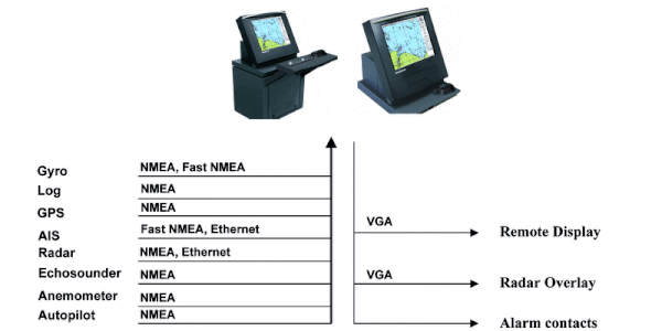
COMPASS • ROT • AUTOPILOT • STEERING • RAI • RADAR • ECDIS • SPEEDLOG
ECHOSOUNDER • DGPS • AIS • WIND • GMDSS • MULTI • VDR • SAILOR